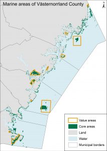
Using GIS analyses, valuable areas for physical planning and management were mapped in the Västernorrland County’s marine environment. The Mosaic framework was used for spatial prioritization.
 The county administrative board in Västernorrland hired AquaBiota to develop a basis for their work on marine green infrastructure. There was a need for increased knowledge about the county’s conservation values and how they could be enclosed to reach a representative network of valuable marine areas.
The Mosaic framework was used as the method for finding areas to prioritize in spatial management. From previous work with Mosaic, there was a draft of a preparatory conservation value assessment, which was reviewed and revised in cooperation with the county administrative board.
All relevant existing data in the form of GIS files were compiled. This included maps of benthic species and habitats, birds and fish. These were used in spatial analyses together with values from the conservation value assessment to map core areas (“värdekärnor”) and value areas (“värdetrakter”) in the county.
Finally, we analysed how well the different species and habitats were represented in the suggested areas, i.e. how many of them were found inside or outside the areas.
Based on this analysis, the areas were adjusted so that they better contributed to a representative network of valuable marine areas.
Project duration: 2017 – 2018.
The result will provide support for marine value assessments in the marine parts of the Västernorrland County.